Posts

Greece's Main Natural Hazards

Image
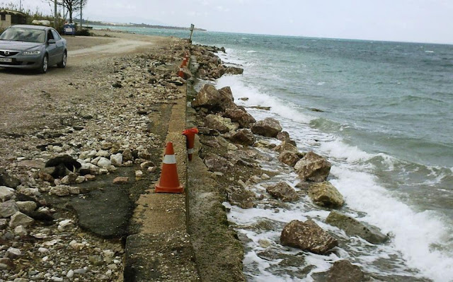
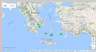
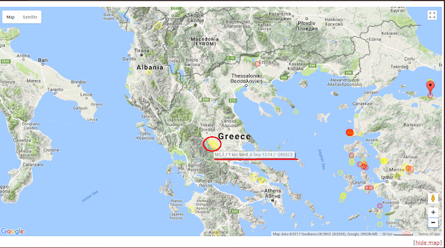
There are several natural hazards and threats that can affect the beautiful country that is Greece. However, two of the largest threats to the country in terms of mother nature's fury are earthquakes and volcanoes. These two hazards have caused great damage throughout history. Greece is located in the Mediterranean Sea and is one of the most seismically active countries in the world. Greece ia seismically active due to its unique location in between tectonic plates. It sits in between the Eurasian, Aegean, and African plates, which are all constantly moving against one another at speeds of up to 30 millimeters per minute. This constant movement triggers seismic activity up in the northern and central areas of Greece. As a result, several earthquakes are bound to happen, some small, others large and destructive. Down below is an image depicting Greece's location within its surrounding tectonic plates. The Greek island of Kos experienced a terrible earthquake back in July of 2

Coastal Hazards in Greece

Image
Aside from floods and tsunamis, Greece also encounters another coastal hazard known as erosion. Erosion is in definition, the wearing away of land and the removal of beach or dune sediments. This hazard happens very frequently in several coasts around its countries islands. Greece's coastline stretches over 15,000 kms in which four coastal types are found. Hard rock coasts, soft rock coasts, beach zones, and mud coasts. One of the largest vulnerabilities is happening in the Greek Hellenic Arc, which right now, 28.6% of it has eroded. Furthermore, in a case where the seal level rises up to 1.8 mm/year due to climate change, the result would be immensely hazardous. Almost half of the Aegean coast would be incredibly vulnerable to erosion. In order to try and mitigate this problem, Greek engineers have created solutions. They have built seawalls, breakwaters, revetments, and flood embankments in order to protect the coasts from further erosion. As of right now, over 15% of its coasts

Extreme Weather in New Zealand

Image
Earlier in the year, New Zealand was hit with a "weather bomb" according to an article published by New Zealand's The Guardian . The heavy storm caused several damages including flooding major rural areas, power outages, and river overflows. The rainfall also caused several landslips, one that unfortunately buried some hot pools located in Dunedin. Fortunately, no citizens were harmed, and some even took advantage of the heavy rainfalls and went out in the streets to take a swim. Experts and researchers have analyzed the storm and they concluded that it is caused by a burst of hot air coming out of Australia that picks up moisture and intensity. This heat wave brought heavy rains and winds to the New Zealand coasts. Down below we can observe some of the significant damages this extreme storm caused.  Reference:  https://www.theguardian.com/world/2017/jan/23/new-zealand-weather-bomb-summer-snow-flooding 

Sinkholes in Greece

After reading several articles on the status of Greece’s sinkhole situation, I learned that most of the sinkholes formed in the country are due to earthquakes and natural gas explosions. For example, there was a huge sinkhole that opened up just last year 18 miles western of the city of Loannina in Greece. The sinkhole measured up to 30 meters in depth and a surface area of 200 meters. Experts & researchers believe the sinkhole was caused due to a series of earthquakes that occurred the week prior to its formation. Authorities in the area confirmed no injuries were reported even though the sinkhole was located within a rural area. Greek researchers have been using USGS to further examine potential risk areas and therefore they contact authorities in order to create safety protocols and procedures so that the people can prepare in case such events occur. Reference:  https://watchers.news/2016/10/22/sinkhole-ioannina-greece/

Mass Wasting Hazards in Greece

Image
Located south west of Greece, lies the island of Santorini. In Santorini, people have been facing mass wasting hazards in frequent occasions. Due to its abundance of highly sloped mountain ranges, landslides, rock falls, and mudslides are happening throughout the place damaging roads and homes. These instances are happening often due to the gravitational pull pushing down the unstable rocks down the cliffs. Another factor includes how these mountains are formed. They are layered with both hard and soft rocks, therefore these cliffs become less stable over time and become more prone to such hazards. Greek authorities are trying to prevent such hazards by adding reinforced steel fencing and netting around touristic cliff sights that people visit frequently. These fences add stability and security that help prevent any sorts of rock falls. In addition, they are also adding more warning signs for areas that do not have such supporting equipment that are at risk of causing hazards. Nonethel

Greece's Volcanic Activity

Image
Greece has a total of six volcanoes whos names are Kolumbo, Methana, Milos, Nisyros, Santorini, and Sousaki. Kolumbo is an acitve submarine volcano located just eight kilometers southeast of the Santorini Island within the Aegan Sea. Its cone is a massive 3km wide with a 500 meter deep 1.5 km crater. Its highest parts reach at approximately just 15 meters below sea level. Its current status is dormant, meaning that it has not erupted in a very long time, however, it is known that its last eruption was very large and happened around 1650 AD. This eruption killed around 70 people in Santorini and its ash reached all the way to Turkey. Methana is also another dormant volcano located in the northwestern part of the country. Its lava domes are 740m wide. This volcano formed the Methana volcanic system which contains around 32 lava domes. In addition, Milos is a volcanic island located in the southern Aegean Sea who's also dormant, however it contains high hydrothermal activity under the

Seismicity in Greece and Safety Procedures

Image
Image source: https://www.volcanodiscovery.com/earthquakes/greece.html The red circle in the image above is showing the seismic activity in Greece this past Wednesday September 6, 2017. The central area of the country experienced three relatively compact earthquakes of magnitudes 3.5 & 3.6. Fortunately, no major damage was reported. Greece is aware of the potential seismic risks that can occur. Therefore, scientists are constantly researching and also recording the active mature faults that are accumulating energy. When scientists discover faults with lots of accumulated energy it means that a potentially strong earthquake has delayed. As a result, this allows government and agency officials to immediately carry out pre-earthquake inspections and reinforcements on vulnerable areas such as older buildings, neighborhoods, schools, etc... Greek scientists prepare for Faults Reference: http://greece.greekreporter.com/2016/08/29/greek-seismologists-we-must-be-prepared-for-faults-w